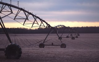
Crop type mapping using LiDAR, Sentinel-2 and aerial imagery with machine learning algorithms
by Atman Prins The second experiment used the methods developed for the first experiment to perform a five-class classification. The five classes consisted of maize, cotton, groundnuts, orchards and non-agriculture. Sentinel-2 and aerial imagery [...]
CITRII – Burgersford Citrus Orchards
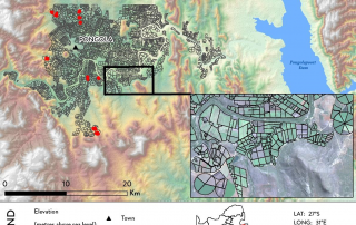
This video is a flyover showing the results of a satellite image (WorldView-2 dated 15 March 2020) analysis of a citrus orchard draped over the Digital Elevation Model of South Africa at [...]

VIDEO #03 | THE TERRACLIM PROJECT | WHAT’S NEXT?
Wynland has released part three of Winetech's flagship project, TerraClim, being undertaken by the CGA. For many wine grape producers in South Africa, access to accurate and [...]
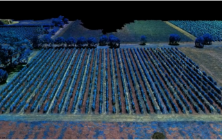
Dense Point Cloud of Vineyard
This is a dense point cloud of a vineyard created with drone imagery with 4 bands (green, red ,red edge and near infrared). The imagery is displayed in false colour using the green , red [...]
CGA and SASRI remote sensing in sugarcane research published
Prof Adriaan van Niekerk and Jascha Muller of the Centre for Geographical Analysis (CGA), and Dr Abraham Singels of the South African Sugarcane Research Institute (SASRI), have published their collaborative research assessing the use of [...]
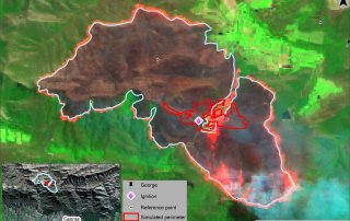
Assessing the ability of the Prometheus Fire Simulation Model to predict fire spread based on the 2018 George fire
By Lauren McCarthy Wildfires occur globally, destroying thousands of hectares of vegetation, affecting ecosystems, the environment, and humans. Fire spread models, based on fire behaviour algorithms, have been developed in different regions to aid [...]