These last few weeks have been really cold, and this week is no different. Based on TerraClim’s climate database, there is a marked difference between this year’s weather compared to last year. But you may be surprised to learn that this year’s temperatures are not colder than the long-term (100+ years) average. For instance, the long-term average minimum July temperatures for Paarl/Wellington, Grabouw/Elgin and Touwsrivier are 7.0°C, 5.3°C, 2.6°C respectively. In July 2021 the average minimum temperatures for these areas were 8.8°C, 6.1°C, and 3.7°C respectively. So the temperatures for July 2021 were on average consistently higher (warmer) than the long-term averages. It feels colder now because it has been a while since we have had such “normal” cold temperatures and we have acclimatised to warmer than usual winters over the last few years.
Apart from the fact that we are not used to this “normal” cold weather, we are increasingly seeing large seasonal changes with certain months (January, June, August and October) of the year. Shifts in the maximum and minimum temperature daily profiles are observed, with the number of hours per day at those extreme temperatures changing. For instance, June 2020 was significantly warmer (in several areas in the Western Cape) than the norm – with both higher minimum and maximum temperatures – while July 2020 was more comparable to the long-term mean. In contrast, August 2020 temperatures were colder than the long-term maximum and minimum averages. In 2021, June, July and August temperatures were closer to the norm, but cooler than the last five seasons. Such seasonal variations are increasing, with certain months (especially June and August) showing large variations from season to season. In addition to these changing ambient temperature profiles, the total rainfall and number of rain days are also showing large seasonal variability.
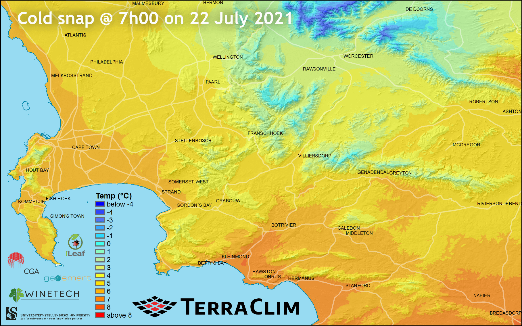
Individual cold and hot spells (events) are also increasing, both in terms of their intensity and duration. These are very difficult to forecast, simply because they do not follow historical patterns. Additionally, the varying topography of the Western Cape makes this even more difficult to model, because temperatures tend to decrease with higher elevation. Along the coast, temperatures are more moderate, but as one moves further away from the ocean, minimum temperatures during winter tend to decrease. So the cold snaps that we are observing in the mountainous areas, as well as on the escarpment (Karoo), are a combination of macro climatic conditions (e.g. frontal systems), distance from the ocean and topography (elevation). For instance, on 22 July 2021 there was a cold snap that resulted in temperatures below -4°C in some high-lying areas (see map). TerraClim’s main focus is on mapping and analysing these factors in order to identify specific areas that are most at risk to these events.

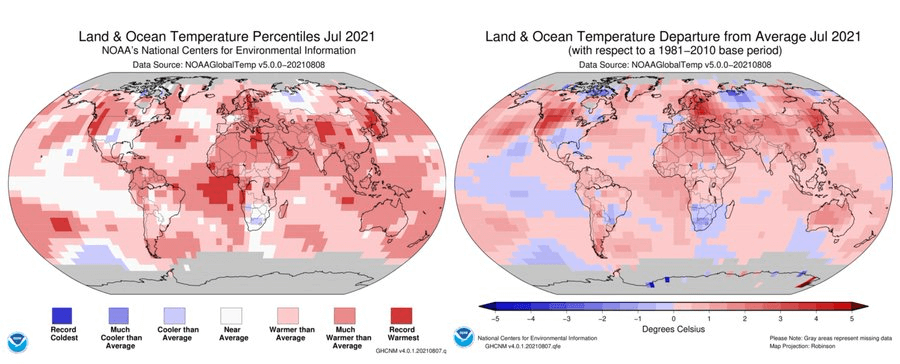
It is very difficult to predict what the climate will be like in the foreseeable future because temperatures are influenced by global weather systems which are poorly understood. Many scientists believe that the large seasonal variations that we are seeing are the response to global warming. At a global level, July has been reported as the earth’s hottest month on record by NOAA’s National Centers for Environmental Information. Based on their data, this year’s Western Cape winter temperatures and rainfall have been on par with long-term means (see figure below), although – compared to the past few seasons of abnormal warmer and drier conditions – it feels much colder and wetter!

TerraClim’s data shows that we can expect increasing seasonal variability. The profile of temperatures is changing in the extremes and we are seeing increases/decreases in the maximum and minimum profiles of a day and the number of hours within those profiles. These changes accumulate over a season and have a direct impact on the biological systems at the farm level. This is problematic for agriculture, particularly for the wine and fruit industries of the Western Cape. The best strategy for producers is to make use of decision-making tools such as TerraClim to review the seasonal climatic profiles of specific areas and comparing them to previous seasons. This aids the effective management of available resources and reduces risks.
Farmers are also encouraged to establish weather stations on their farms if none are available in the area. Farmers with weather stations receive location-specific forecasts about frost, pests, disease, heat-wave warnings etc. There are a number of local organizations that can help farmers in this regard. For instance iLeaf operates a network of more than 200 weather stations throughout the Western Cape and has much experience with setting up and maintaining stations. TerraClim makes use of this network to produce climate profiles for every farm in the south-western Cape. Please check out www.terraclim.co.za.
Acknowledgements:
TerraClim is funded by Winetech, is developed by the Centre for Geographical Analysis at Stellenbosch University and is currently being commercialized (incubated) through Geosmart Space. Weather station data is provided by iLeaf.

