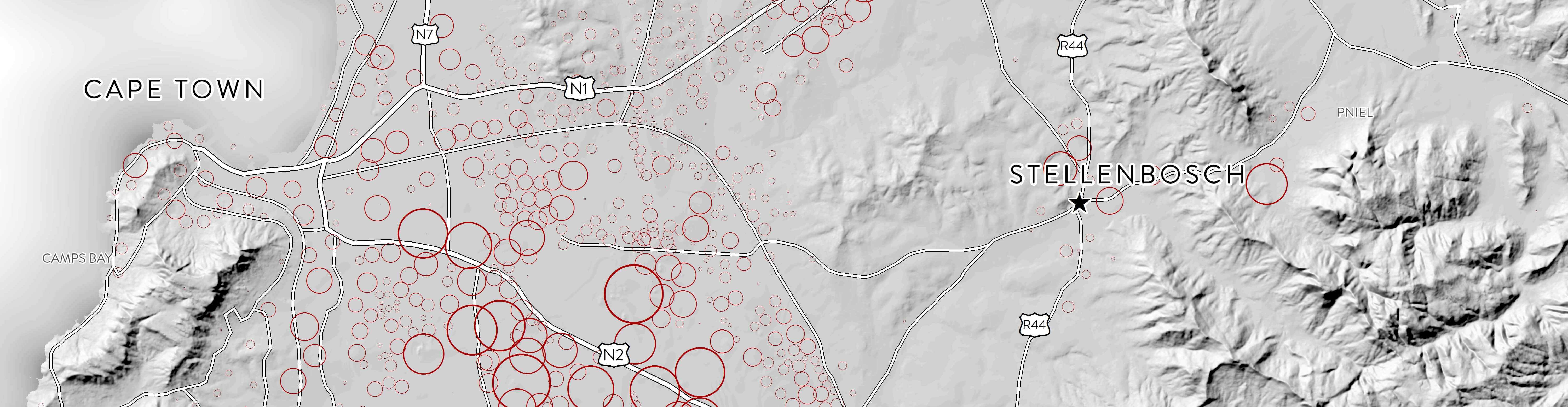
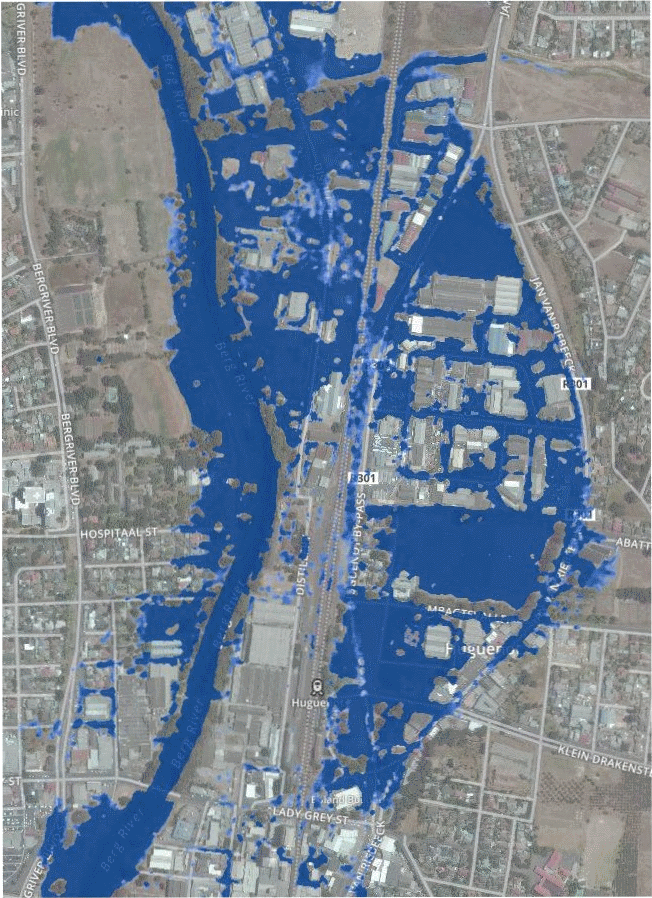
Changes in surface water area of Voëlvlei Dam from October 2016 to 22 March 2017

Changes in surface water area of Voëlvlei Dam near Gouda from October 2016 to 22 March 2017 as represented by a normalized difference moisture index (NDMI). The images, captured by the Sentinel-2 satellite, show relative moisture levels with dark blue representing wet areas (water) and red/orange shades representing dry areas.  Voëlvlei Dam is one [...]

Changes in surface water area of Voëlvlei Dam from October 2016 to 22 March 20172017-10-31T11:30:50+02:00

The CGA begins work on Phase 1 of land audit for Stellenbosch Municipality

In September 2016, Stellenbosch Municipality and the Centre for Geographical Analysis (CGA) at Stellenbosch University embarked on a collaborative effort to share GIS data and services. As part of this collaboration, a comprehensive land audit for all properties within the Stellenbosch Municipal Area will be carried out. Phase 1 of this project commenced [...]

The CGA begins work on Phase 1 of land audit for Stellenbosch Municipality2017-10-31T11:34:20+02:00

ESTIMATION OF TOTAL WATER USE BY IRRIGATED AGRICULTURE

The CGA, in partnership with eLEAF ®, Agricultural Research Council, GeoTerra Image and several independent consultants, is currently carrying out research funded by the Water Research Commission (WRC) and the Department of Agriculture, Forestry and Fisheries (DAFF) to estimate the total water used by irrigated agriculture. Earth observation data (e.g. satellite imagery) is [...]

ESTIMATION OF TOTAL WATER USE BY IRRIGATED AGRICULTURE2018-08-21T12:47:49+02:00

Trimble enters into Imaging Program with CGA

Trimble Navigation Limited, the owners and developers of geographic object-based image analysis (GEOBIA) software eCognition Developer, eCognition Essentials and eCognition Server, has appointed the Centre for Geographical Analysis (CGA) of Stellenbosch University (SU) as an innovation partner in their Trimble Imaging Innovation Program. The first agreement of this type in South Africa, the [...]

Trimble enters into Imaging Program with CGA2017-10-31T12:51:16+02:00

Successful launch of the Sentinel-2B satellite

We are excited about the successful launch of the Sentinel-2B satellite which will join Sentinel-2A to provide us with a 5 day revisiting period. Check it out: Sentinel-2B is the second satellite in the Sentinel-2 mission for Europe’s Copernicus environment monitoring programme. Designed as a two-satellite constellation – Sentinel-2A and -2B – the Sentinel-2 [...]

Successful launch of the Sentinel-2B satellite2019-08-08T11:28:32+02:00

Web-based road-accident and road-condition data integration

The CGA, in collaboration with the Department of Civil Engineering at Stellenbosch University, recently completed a web mapping project for the Provincial Government of the Western Cape (PGWC) relating to accident hotspots on provincial roads. The aim was to integrate data on road conditions and characteristics provided by PGWC’s Road Network Information System (RNIS) [...]

Web-based road-accident and road-condition data integration2017-10-31T13:02:52+02:00

PCI renews Strategic Education Alliance Agreement with Stellenbosch University

PCI Geomatics Enterprises Inc., the developers of the remote sensing software PCI Geomatics and PCI GXL, have extended their Strategic Education Alliance Agreement with Stellenbosch University (SU) for another year. Now entering its second year, this agreement recognises SU as the sole PCI Technology Centre of Excellence in Remote Sensing and Geomatics in South Africa. [...]

PCI renews Strategic Education Alliance Agreement with Stellenbosch University2017-10-31T13:04:42+02:00

2017 Course dates

Our short course dates for 2017 have been set. Click here for more information and make sure to book your spot. Limited spaces are available. 08 – 12 May 2017 – Introduction to GIS 14 – 18 August - Introduction to Earth Observation (Remote Sensing) 18 – 22 September – GEOBIA (eCognition) 16 – 20 October – Introduction to [...]

2017 Course dates2017-10-31T13:08:17+02:00

Development of a provincial flood-hazard index for the Western Cape Province

The CGA recently created a terrain-based Provincial Flood Hazard Index (FHI) of the Western Cape by using the Stellenbosch University digital elevation model (SUDEM). The overall purpose of the FHI is to improve: risk reductions measures flood preparedness spatial planning The development process for this project was as follows: the SUDEM was prepared for [...]

Development of a provincial flood-hazard index for the Western Cape Province2017-10-31T13:21:34+02:00

German exchange students

The CGA recently welcomed two earth observation students from the Friedrich Schiller University of Jena in Germany. Eric Krüger and Stefan Werner are both doing BSc degrees that require three months of vocational experience. Following in the footsteps of previous Jena students, they capitalized on the established relationship between the Earth Observation Departments of [...]

German exchange students2017-10-31T13:24:27+02:00
Go to Top