
The 5m resolution Stellenbosch University Digital Elevation Model (SUDEM) makes use of an innovative algorithm to maximise accuracy and minimise interpolation artefacts. Three sets of input data were used to generate the SUDEM, namely 1:10000 contours and spot heights, 1:50000 contours and spot heights, and the 30m SRTM DEM. The contours and spot heights were obtained from the Chief Directorate: National Geospatial Information, while the 30m SRTM DEM was obtained from the USGS.
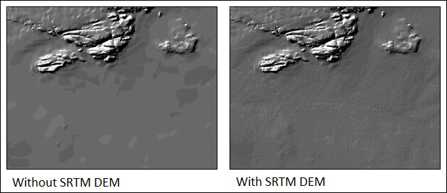
Much of the effort expended in developing the SUDEM related to correcting errors in the contour and spot height data. Preference was given to large scale (i.e. 1:10000) contours and spot heights, while smaller scale (i.e. 1:50000) data were only used in areas where large scale data were unavailable. Two products were developed from this data. The Level 1 product was interpolated using only contours and elevation points, while the Level 2 product combines contours and elevation points with the SRTM DEM. For Level 2 the SRTM DEM is only applied in areas with low contour densities and spot heights (i.e. areas with low slopes). A novel technique was developed to ensure that the different DEMs are fused without producing artefacts.
The incorporation of the SRTM DEM into the Level 2 product significantly improves the quality of the resulting DEM (see figures below).
The SUDEM is currently the highest resolution DEM of South Africa and has been shown to be superior to other DEMs for a range of applications (see link below).
Research papers/dissertations:
For more information on the SUDEM, please visit https://geosmart.space/products/sudem.html