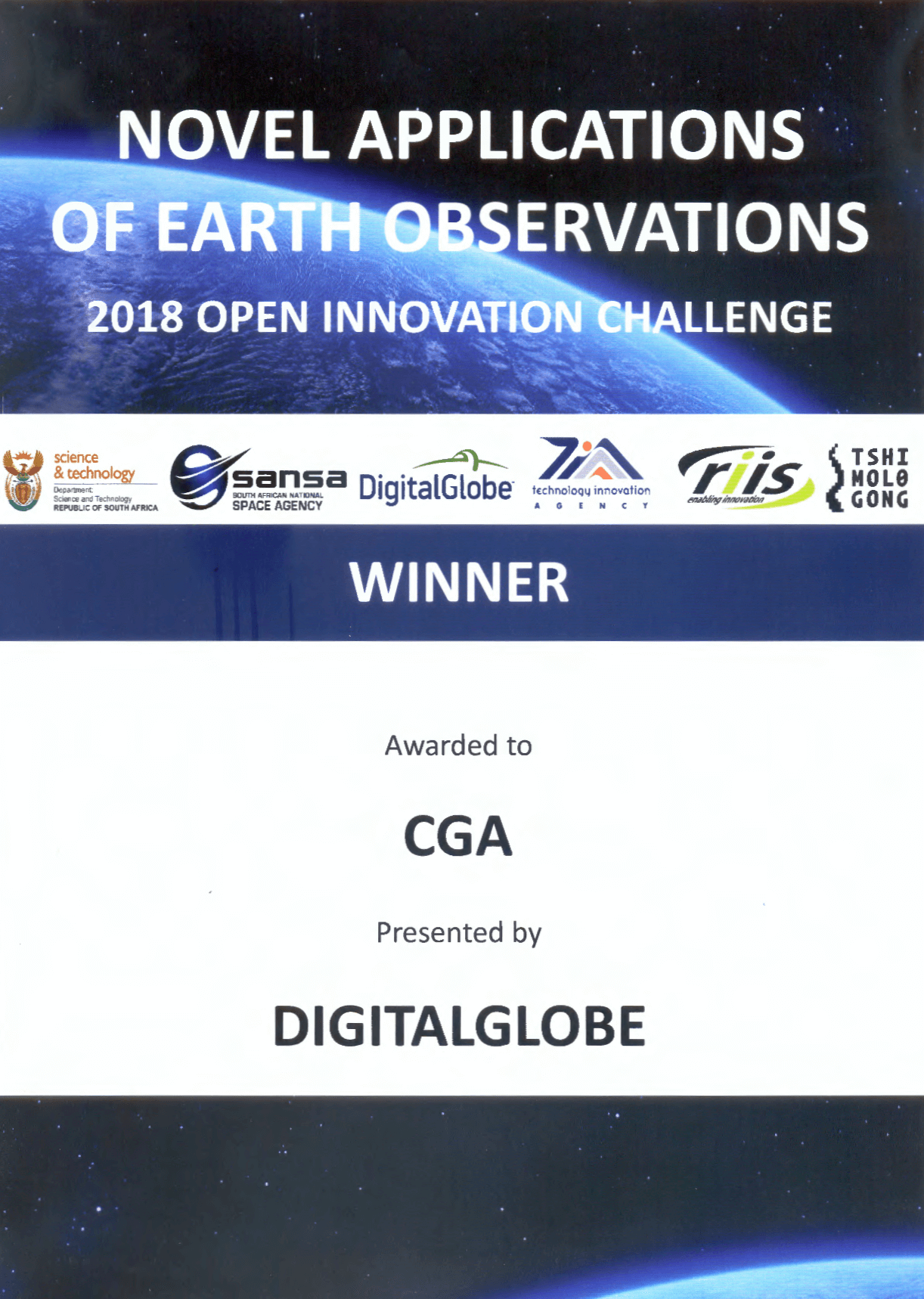
SAEO challenge

The CGA is proud to be one of the winners of the SAEOchallenge! It seems that the judges agreed that our earth observation technology to map and monitor water use of irrigated agriculture at national scale is highly innovative. We hope that this exposure will lead to the [...]

SAEO challenge2018-12-07T12:31:43+02:00

Advanced GEOBIA Workshop

The CGA is excited to be hosting an Advanced GEOBIA workshop with guest trainer Keith Peterson, Product Manager eCognition Trimble Inc. Germany. Themes that will be covered include convolutional neural networks; customised algorithms; point cloud & vector analytics, machine learning algorithms; and template matching. For more information please visit the events page. [...]

Advanced GEOBIA Workshop2018-10-11T13:07:49+02:00

WRC publishes irrigated water use report

The four-year CGA project for the WRC, An Earth Observation Approach towards Mapping Irrigated Areas and Quantifying Water Use by Irrigated Crops in South Africa, has been published by the WRC and is now available online. Various assessments since 1990 have documented area of the irrigated crops in South Africa. However the [...]

WRC publishes irrigated water use report2018-10-09T09:45:08+02:00

Introduction to Earth Observation Short Course – August 2018

The CGA presented their Introduction to Earth Observation short course from 13-17 August 2018, which was attended by 16 delegates. This course is aimed at beginners to earth observation, and teaches the basic principles and techniques fundamental to remote sensing. Themes covered in this course include: the principles of remote sensing and [...]

Introduction to Earth Observation Short Course – August 20182018-08-21T14:00:59+02:00

CGA Map Competition Winners!

Congratulations to our Map Competition winners! First place - Ockert Malan Second place - Jano Barnard Third place - Christiaan Theron The CGA would like to thank Dr Jaco Kemp, Jan De Waal, Mrs Zahn Munch for serving as the panel of judges, as well as everyone who participated and submitted their [...]

CGA Map Competition Winners!2018-08-21T09:58:42+02:00

Theewaterskloof is on its way to recovery

With the good rains in May and June, Theewaterskloof is on its way to recovery. The biggest dam in the Western Cape Province, Theewaterskloof, was sitting at 39% capacity on Monday 9th July 2018. This is double of what it was last year at the same time (19.5%). The GIF below is a [...]

Theewaterskloof is on its way to recovery2018-07-12T14:18:30+02:00

Junior Web/Software Developer

Junior Web/Software Developer (Four months contract appointment) (Ref. LSW20/135/0418) The CGA specialises in the application of geographical information systems (GIS), satellite remote sensing and other geographical-analytical techniques to carry out research, training and service provision functions in this field. Duties: The role is primarily a support position within the CGA team, with a focus on [...]

Junior Web/Software Developer2018-04-25T14:32:06+02:00

GeoSmart

GeoSmart Space, a spin-out company established by the CGA in conjunction with InnovUS, recently launched its new website. The purpose of the company is to commercialise the CGA’s intellectual property and products. For more information, see InnovUS’ latest newsletter here. To go directly to the new website, please click here. [...]

GeoSmart2018-01-29T10:03:00+02:00

2017 Highlights

As we kick off another year, the CGA would like to wish all of their clients and collaborators a happy 2018! Last year was a busy one for the CGA, with the successful completion of a number of projects, short courses, research and development. Specific highlights of 2017 include: the submission [...]

2017 Highlights2018-01-24T13:16:48+02:00
Go to Top