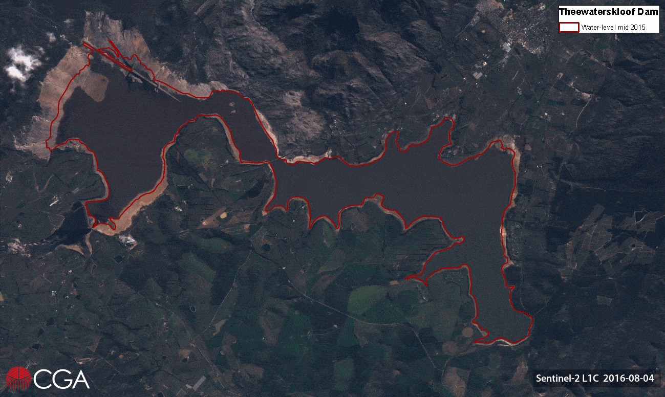
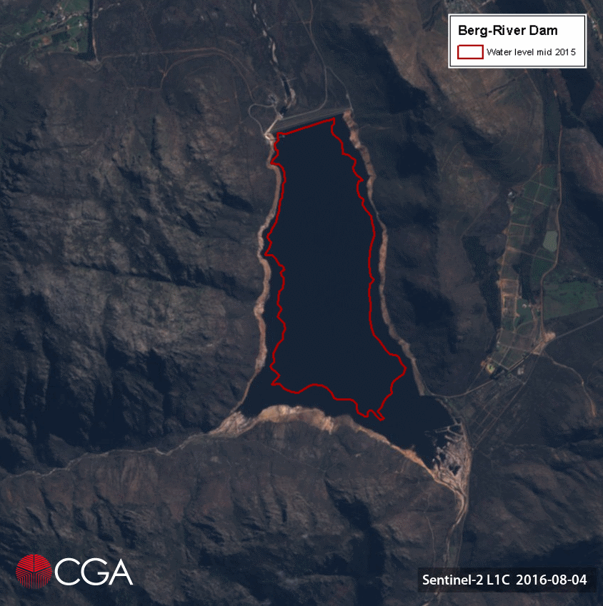
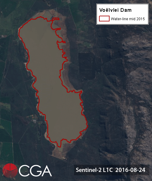
2017 Highlights

As we kick off another year, the CGA would like to wish all of their clients and collaborators a happy 2018! Last year was a busy one for the CGA, with the successful completion of a number of projects, short courses, research and development. Specific highlights of 2017 include: the submission [...]

2017 Highlights2018-01-24T13:16:48+02:00

Article in the WRC Water Wheel Magazine

The mapping of irrigated agriculture from earth observation imagery, an outcome of the WRC-funded research project Wide-scale modelling of water use and water availability with earth observation/satellite imagery, was recently published in the WRC Water Wheel Magazine. The article, written by Sue Matthews and titled Project modelling irrigation water use through satellite technology [...]

Article in the WRC Water Wheel Magazine2018-08-21T12:45:59+02:00

MESA receiving station is now operational

The CGA’s receiving station for MESA (Monitoring for Environment and Security in Africa), is now operational! In the first week of September, Motlotlegi Pilane, a representative of MESA, visited the CGA to repair the receiving station’s satellite dish. Stellenbosch University was named a beneficiary institution of the MESA programme for the Southern [...]

MESA receiving station is now operational2017-10-26T14:59:37+02:00

GISSA quarterly meeting

On the 20th of September five Students from Stellenbosch University presented their research and findings to the GIS community at the Western Cape GISSA quarterly meeting in Durbanville. Michael Johnson (MSc) – Extraction of coastal ocean wave characteristic parameters using multispectral remote sensing and computer vision technologies. Gerrit Low (PhD) – Object-based terrain [...]

GISSA quarterly meeting2017-10-31T09:10:14+02:00

Introduction to GEOBIA, presented at CSIR, Pretoria

The CGA presented its Introduction to GEOBIA short course to the Environment (NRE) Ecosystems Earth Observation Research Group at the CSIR campus in Pretoria from 14-17 August. The course was presented as part of the Trimble Innovation Programme (TIP) of which the CGA is an active member. The GEOBIA training made use of [...]

Introduction to GEOBIA, presented at CSIR, Pretoria2017-10-31T09:31:31+02:00

Satellite image time-series of main dams supplying Cape Town with water – Wemmershoek Dam

The final dam considered in our satellite time-series is the Wemmershoek Dam. Located between Franschhoek and Paarl in the Wemmershoek mountains, this earth-fill dam is one of the smaller dams supplying water to Cape Town, with a capacity of 58644 Ml. Currently at 40% capacity (in comparison to 69% this time last year), [...]

Satellite image time-series of main dams supplying Cape Town with water – Wemmershoek Dam2017-10-31T09:37:03+02:00

Satellite image time-series of main dams supplying Cape Town with water – Theewaterskloof Dam

The largest dam in the Western Cape, namely Theewaterskloof Dam, is the next dam being considered in our satellite time-series. Established in 1978, the earth-fill dam was constructed in the Riviersonderend River near Villiersdorp, with the mountains of the Hottentots-Holland Nature Reserve serving as the primary catchment. With a capacity of over 480 [...]

Satellite image time-series of main dams supplying Cape Town with water – Theewaterskloof Dam2017-10-31T09:40:28+02:00

Satellite image time-series of main dams supplying Cape Town with water – Berg River Dam

The Berg River Dam, the most recently established large dam supplying Cape Town with water. The 68 m tall, concrete-face rockfill dam with a capacity of 130 million cubic metres makes up 14% of the water storage capacity in the Greater Cape Town Region. Planning of the dam began in 1989, with extensive social and environmental impact studies undertaken before ground [...]

Satellite image time-series of main dams supplying Cape Town with water – Berg River Dam2017-10-31T09:42:23+02:00

Satellite image time-series of main dams supplying Cape Town with water – Voëlvlei Dam

Second only to Theewaterskloof Dam in capacity, Voëlvlei is the third dam being considered in our satellite image time-series. Commissioned in 1952, the dam was constructed by impounding the natural Voëlvlei lake near Gouda, creating the first large water supply scheme in the Berg River catchment. Due to the relatively small size of the catchment, additional water is abstracted to the dam from [...]

Satellite image time-series of main dams supplying Cape Town with water – Voëlvlei Dam2017-10-31T09:43:53+02:00
Go to Top